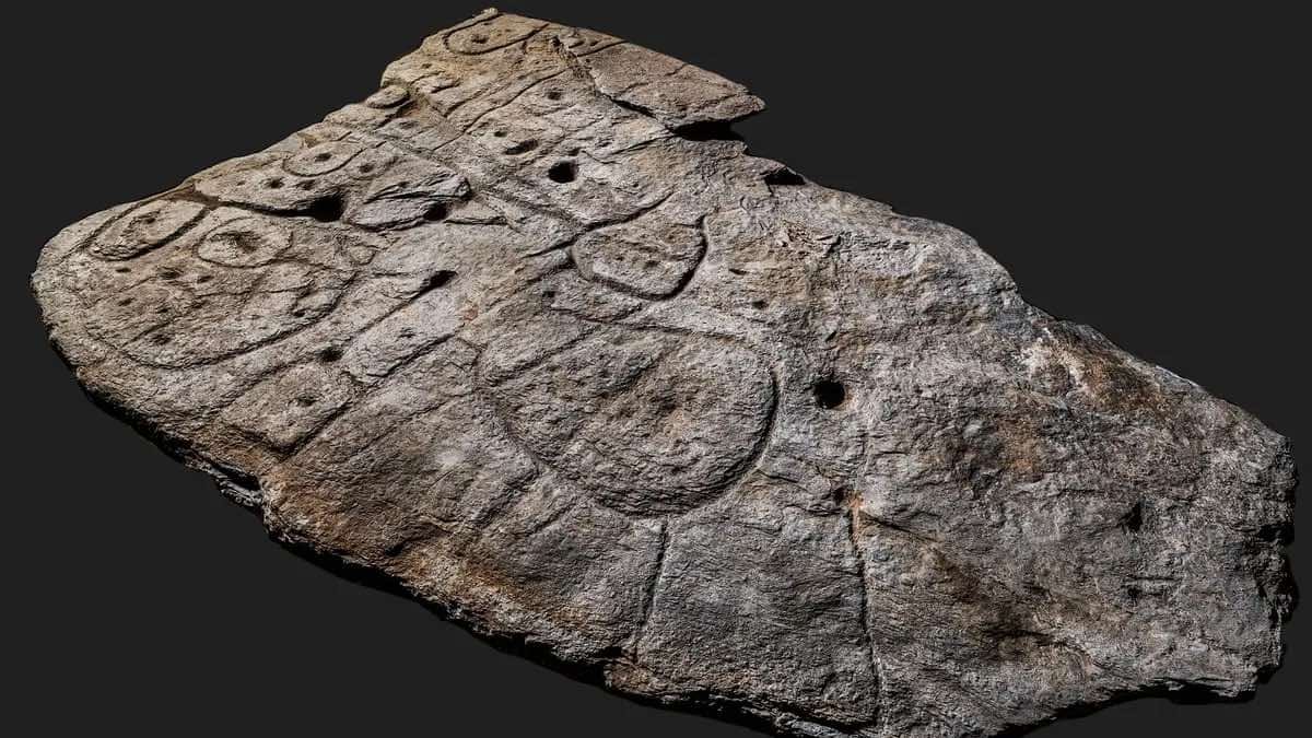
An ancient stone covered in markings believed to represent the oldest map in Europe is revealing new secrets, according to findings that archaeologists believe could lead them to new ancient discoveries.
First discovered in 1900, the Saint-Bélec slab is a 4,000-year-old carved stone fragment found in an ancient burial mound in the Leuhan parish near France’s Finistère Department. Although a portion of the slab’s upper part is missing, most of the relic managed to survive since its creation sometime between 2150 and 1600 BCE.
Believed to be Europe’s oldest map, and possibly one of the oldest maps of any territory that hails from such an early period, the curious stone, at slightly under four meters in length and just over two meters wide, appears to chart a region of ancient western Brittany.
Now, archaeologists believe that following clues the enigmatic stone and its markings may offer could serve as a veritable “treasure map,” which may lead them to the locations of as-yet undiscovered archaeological sites.
Forgotten History
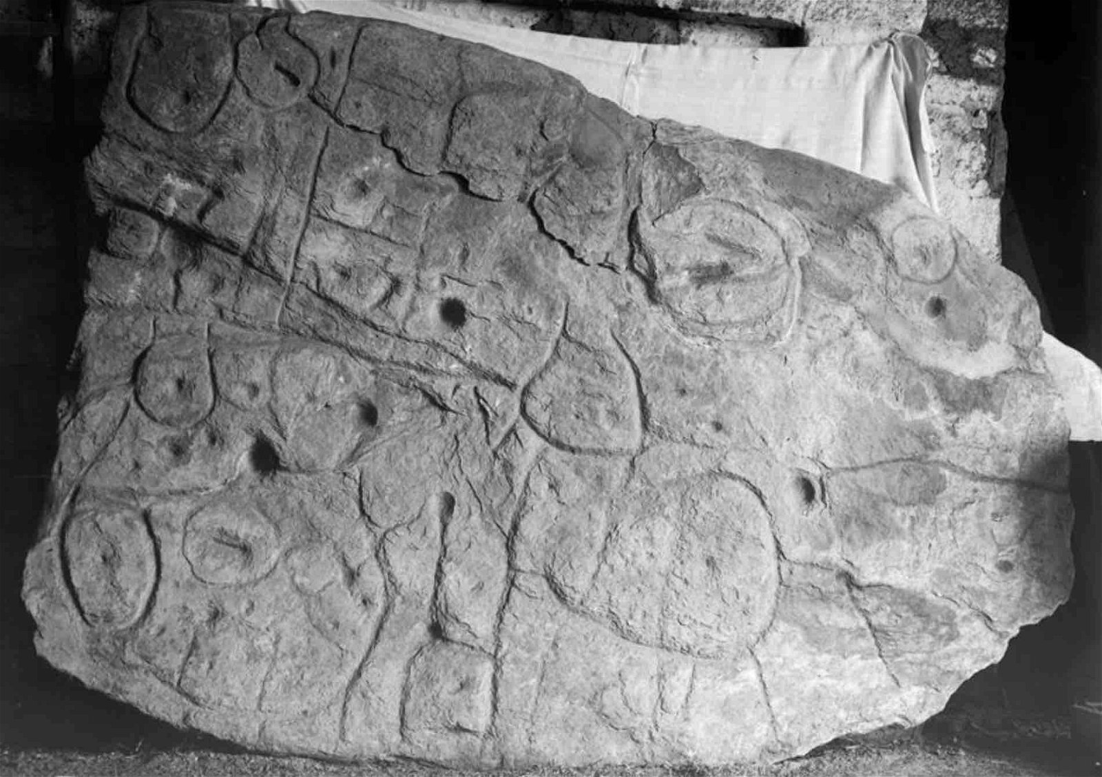
The Saint-Bélec slab was unearthed in 1900 by Paul du Châtellier, a French historical researcher and founding member of the French Prehistoric Society. Initially kept at du Châtellier’s home, it eventually made its way to the French National Archaeological Museum, and sometime in the 1990s was relocated to the facility’s cellar, where it faded from memory for decades.
However, in 2014 the slab was rediscovered, which led to studies beginning in 2017 that eventually identified the ancient carvings as a map depicting the Odet valley as it appeared during the Bronze Age. The slab, composed of a bluish schist, was likely quarried from somewhere near Douarnenez, where similar stone formations exist.
Since it was determined to be the oldest known map of any European territory, efforts have continued since 2021 to try and decipher the meaning behind the stone’s curious etchings.
A Map to Lost Archaeological Treasure
Yvan Pailler, a professor at the University of Western Brittany, is very clear about what he and his colleagues believe the Saint-Bélec slab to be.
“It’s a treasure map,” Pailler recently said.
Pailler believes that the stone’s intended function—as a map of the surrounding region and locations within it—could offer archaeologists a novel method of finding undiscovered archaeological sites.
Today, with access to remote sensing technologies, archaeological sites are often found and explored without the need for excavation. Thanks to the accessibility of satellite imagery, in recent years there have been several significant archaeological discoveries made by researchers who never had to leave their offices, but who managed to discover site locations that otherwise might never have been located.
Pailler and his colleague Clement Nicolas with the CNRS research institute believe that while the markings on the stone were almost immediately identifiable, the groundwork to try and find the locations of all the sites it depicts will likely take more than a decade.
Deciphering Ancient Clues
Among the features that researchers say they recognize on the Saint-Bélec slab are rivers, mountains, and other natural features that are nearly an 80% match when compared to features on modern maps, although some of the symbols remain mysterious.

Certain areas that are depicted on the map are also suggestive of burial mounds, similar to the one from which the slab was unearthed more than a century ago. If these features are locations of archaeological significance, the stone’s markings could offer researchers an unprecedented means of locating and exploring these sites in the years ahead.
Last month, it was reported that recent archaeological investigations have also been undertaken at the site where du Châtellier originally unearthed the stone, with hopes of obtaining a better idea of the context in which the discovery was made.
Remarkably, several more fragments, albeit small ones, that once belonged to the original slab have been recovered during the recent excavations, some of which, along with the main portion of the slab recovered in 1900, had been used in the construction of a tomb wall.
Although certainly the oldest map known to have been discovered in Europe, the Saint-Bélec slab is one of a handful of similar ancient maps that archaeologists have recovered.
What may be the oldest found anywhere in the world is the Imago Mundi, or the Babylonian Map of the World. Discovered in southern Iraq near the city of Sippar, the map dates to the 5th century BC, and is currently held at the British Museum in London.
Micah Hanks is the Editor-in-Chief and Co-Founder of The Debrief. He can be reached by email at micah@thedebrief.org. Follow his work at micahhanks.com and on Twitter: @MicahHanks.