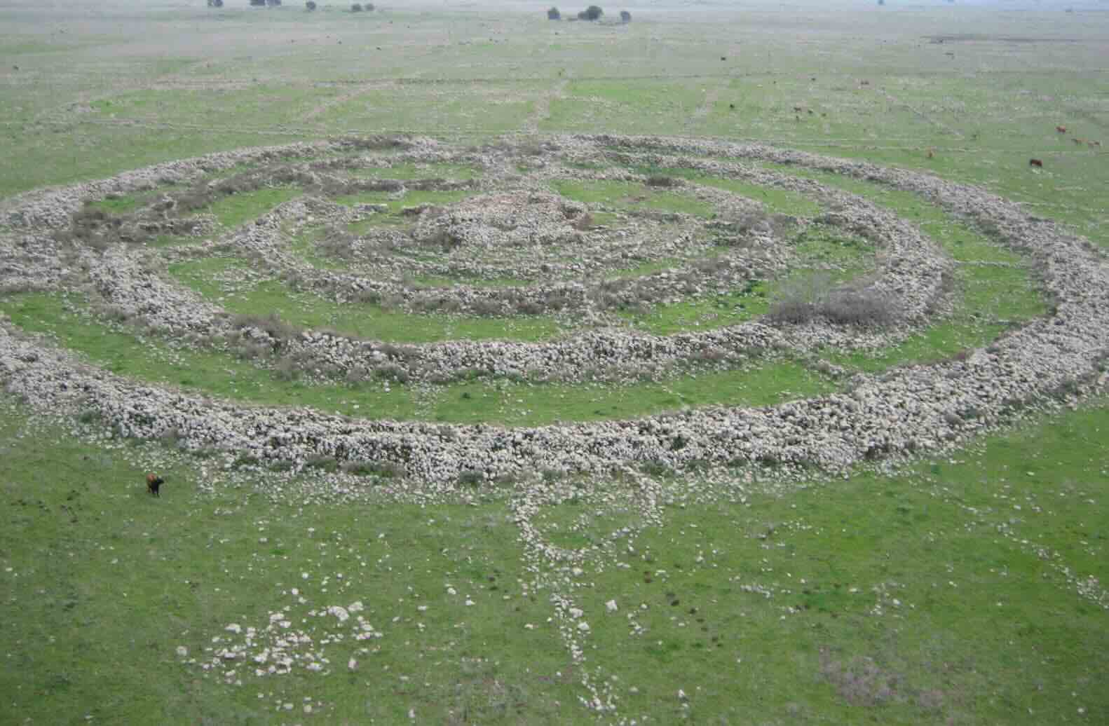
The mystery of Israel’s “Wheel of Ghosts” reopens as new data demonstrates the site’s shifting geodynamics over time undermine its suspected use as an ancient astronomical tool.
The mysterious site in the Israeli-occupied Golan Heights, historically referred to as Rujum el-Hiri but commonly known as the Wheel of Ghosts, is the focus of recent groundbreaking archaeological research aided by geomagnetic sensors. The ongoing work has revealed that over thousands of years, the orientation of the spot has shifted significantly, making any correlation between its modern placement and the current night sky meaningless to its ancient creators.
The Wheel of Ghosts
With a 150-meter diameter and surrounded by a 2.5-meter-high outer wall, the ancient megalithic structure Rujum el-Hiri sits 18 kilometers northeast of the Sea of Galilee. Its 42,000 stones form concentric rings, culminating in a 5-meter-tall mound. Due to the lack of development in the primarily agricultural region, the ancient megalith has remained relatively unmolested and remarkably well-preserved.
Archaeologists date the structure back to the bronze age, circa 3600-2300 BCE, although an origin as far back as 4500 BCE is possible. The earliest known name for the structure, Rujm el-Hiri, comes from ancient Syrian maps and translates to “stone heap of the wildcat.” Modern Hebrew uses the name Gilgal Refaʾim, from which the translation “Wheel of Ghosts” or “Wheel of Spirits” derives. Archaeologists rediscovered the site in the 1960s before its excavations in the 80s and 2000s. Those excavations revealed a complex strata, as various groups used and reused the structure over time.
Sensing at the Wheel of Ghosts
Tel Aviv University geophysicists Dr. Olga Khabarova and Prof. Lev Eppelbaum collaborated with Ben-Gurion University archaeologist Dr. Michal Birkenfeld to lead the study. The multidisciplinary team synthesized several methods in their work, taking advantage of the variety of skillsets present. These included geomagnetic analysis of the magnetic field signatures left in rocks in the soil, tectonic reconstruction of the Earth’s shifting surface, and remote sensing from the US Geological Survey’s Landsat/Copernicus Earth-observing mission.
With the geomagnetic analysis and tectonic reconstructions, the team estimated the site reoriented and rotated at 8-15mm increments every year. Over the 5,000 years of its existence, these small movements would have added up to a tremendous shift by potentially as much as dozens of meters counterclockwise, invalidating any intentionality that archaeologists could derive from its current orientation.
Calculating where these walls could have been at the time of their construction allowed the team to compare the site’s past orientation to matching sky maps from those periods. The team’s analysis demonstrated no alignment between the structure’s walls or entrances and any “solstices, equinoxes, or celestial bodies,” reignighting speculations about the site’s intended purpose.
Foundations For Future Archaeology
While the project casts one archaeological site back into the realm of mystery, it also lays the groundwork for further investigation of the area. The satellite maps that the team generated are the first comprehensive mapping of the archaeological landscape surrounding Rujum el-Hiri. These satellite images allowed the team to identify intriguing new features in the area, including circular structures with 40-90 meter diameters, thick walls, and 20-meter diameter round enclosures, potentially used for agriculture or livestock.
Additionally, the researchers discovered dozens of tumuli mounds dotting the landscape. Tumuli were most often utilized as burial mounds, but builders also employed them for other purposes, such as storage facilities, shelters, or dwellings. Like the Nazca Lines in Peru, this aerial view allowed the team to observe what might not be readily apparent to a human on the ground.
“This new study not only opens a window to understanding Rujm el-Hiri but also enriches our knowledge of ancient life in the Golan Heights and the connections between various archaeological findings in the area,” the researchers conclude.
The paper “Discussion Points of the Remote Sensing Study and Integrated Analysis of the Archaeological Landscape of Rujm el-Hiri” appeared on November 14, 2024 in the Remote Sensing.
Ryan Whalen covers bats exclusively for The Debrief. He holds an MA in History and a Master of Library and Information Science with a certificate in Data Science. He can be contacted at ryan@thedebrief.org, and follow him on Twitter @mdntwvlf.

