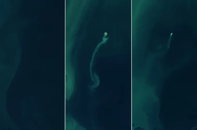
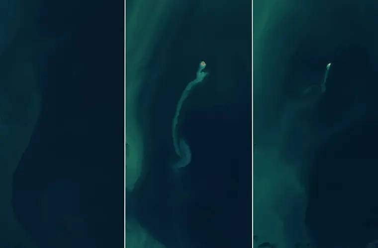
In a remarkable display of Earth’s dynamic geology, NASA satellites have documented the sudden emergence and swift disappearance of a “ghost island” in the Caspian Sea. The event offers a rare glimpse into the transient nature of mud volcanoes and their impact on our planet’s landscape.
In early 2023, the tranquil waters of the Caspian Sea, approximately 15 miles off the eastern coast of Azerbaijan, were disrupted by the eruption of the Kumani Bank mud volcano, also known as Chigil-Deniz.
This geological event led to the formation of a new island, a phenomenon that has intrigued scientists and highlighted the volatile nature of mud volcanoes.
Satellite imagery from NASA’s Landsat 8 and 9, equipped with the Operational Land Imager (OLI) and OLI-2 instruments, captured the island’s brief existence.
In November 2022, the area showed no signs of landmass. However, by February 14, 2023, a distinct island measuring approximately 1,300 feet across had emerged, accompanied by a sediment plume.
Mud volcanoes are geological formations created by the sudden expulsion of mud, water, and gases deep within the Earth’s crust. Unlike magmatic volcanoes, they do not produce lava but can form landmasses through the accumulation of expelled materials. These islands are often short-lived, as the loose sediments are susceptible to erosion by wind and water.
The newly formed island near Kumani Bank exemplified this transience. By the end of 2024, satellite images showed that the island had nearly eroded away, retreating from view like an apparition.


Azerbaijan is notable for its high concentration of mud volcanoes, with more than 300 identified in the region, both on land and offshore in the Caspian Sea. This abundance is attributed to the area’s geological setting, situated within a convergence zone where the Arabian and Eurasian tectonic plates collide. Such tectonic activity facilitates the buildup of subsurface pressures, leading to the formation of mud volcanoes.
The Kumani Bank mud volcano has a history of producing transient islands. Its first recorded eruption in May 1861 resulted in an island measuring just 285 feet across and 11.5 feet above the water, which eroded away by early 1862. The most powerful eruption, recorded in 1950, created an island 2,300 feet across and 20 feet high.
These eruptions can be dangerous, and one of the more dramatic phenomena associated with mud volcanoes is their ability to catch fire during eruptions, though the exact mechanisms remain a subject of scientific curiosity.
It’s currently unknown how a mud volcano can ignite naturally, but one leading theory suggests that the mixture of flammable gases—such as methane and hydrogen sulfide—released during an eruption might ignite due to sparks created by the collision of rocks under high-pressure conditions.
While rare, these fiery displays are a testament to the raw power and unpredictability of geological processes. Occasionally, they produce towering flames visible for miles, underscoring the unique hazards of mud volcanoes.
The phenomenon of disappearing islands is not unique to the Caspian Sea. In 2013, a 7.7 magnitude earthquake off the coast of Pakistan triggered a mud volcano eruption that created a ghost island 65 feet high, 295 feet wide, and 131 feet long near the port city of Gwadar. However, by 2016, the ocean had reclaimed most of the island, leaving it to vanish as abruptly as it had appeared.
Ghost islands’ rapid emergence and disappearance can affect local ecosystems and human activities. While the islands exist, they can provide temporary habitats for various species. However, their sudden appearance can pose navigation hazards for maritime activities, and their erosion can lead to sediment redistribution, affecting local marine environments.
Satellite imagery has been instrumental in observing and understanding these fleeting geological events. Satellites equipped with advanced imaging technology, like NASA’s Landsat series, provide continuous monitoring capabilities, allowing scientists to document changes in Earth’s surface in real-time. This continuous observation is crucial for capturing short-lived phenomena that might otherwise go unnoticed.
The study of mud volcanoes extends beyond Earth. Scientists believe that similar processes may occur on other planetary bodies. For instance, some muddy mounds in the northern lowlands of Mars are thought to have formed when gas- and liquid-rich sediments erupted to the surface, suggesting that mud volcanism could be a common geological process in the solar system.
Ultimately, this recent case of the Caspian Sea’s ghost island underscores the importance of satellite monitoring in studying Earth’s dynamic systems. As technology advances, the ability to observe and analyze such events will enhance, providing deeper insights into the geological processes that shape our planet.
Tim McMillan is a retired law enforcement executive, investigative reporter and co-founder of The Debrief. His writing typically focuses on defense, national security, the Intelligence Community and topics related to psychology. You can follow Tim on Twitter: @LtTimMcMillan. Tim can be reached by email: tim@thedebrief.org or through encrypted email: LtTimMcMillan@protonmail.com

