NASA satellite imagery has revealed the thermal signature of volcanic activity that reawakened on Iceland’s Reykjanes peninsula this month, following an eruption late last year that prompted evacuations.
Following a surge that began in mid-January, new fissures opened near the town of Grindavík that released lava over 48 hours. Barriers constructed in the area helped divert the flow away from the town, which remains perilous as volcanic activity continues.
The recent eruptions were the fifth that have occurred on the peninsula since 2021.
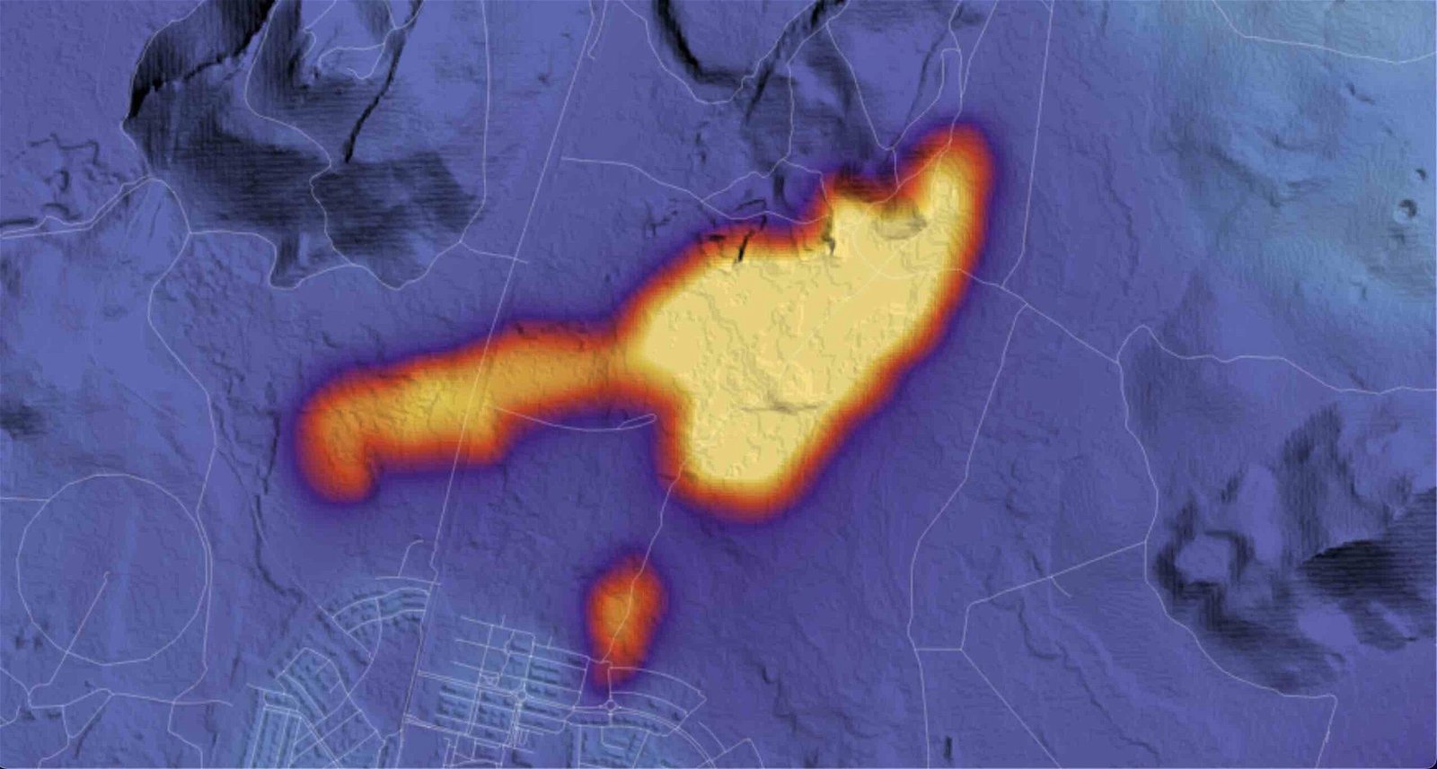
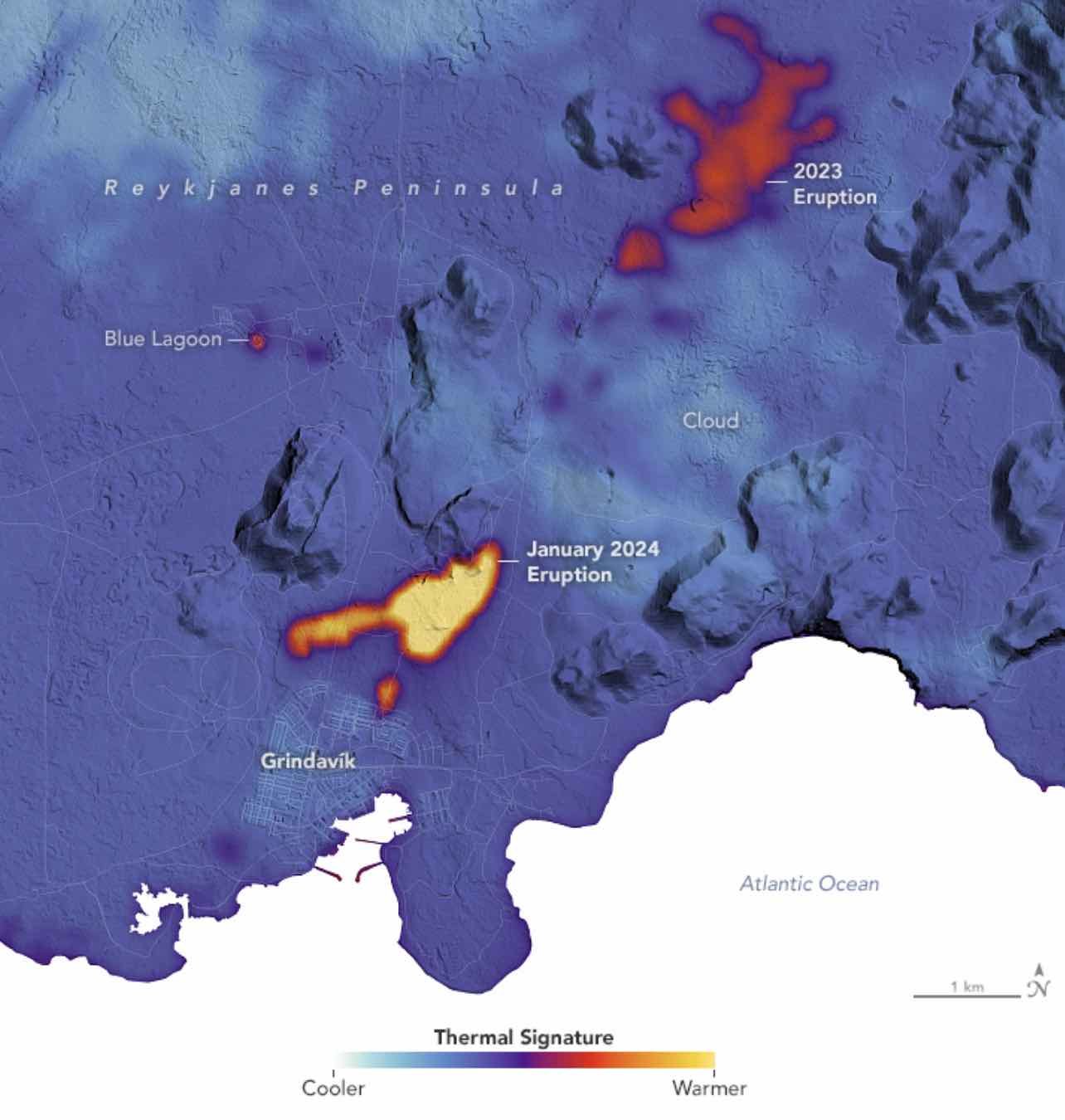
Watching from above as the hazardous activity has unfolded in recent weeks, NASA’s Landsat 9 satellite and its Thermal Infrared Sensor 2 (TIRS-2) instrument have collected data that reveals key areas where the volcanic activity is concentrated.
TIRS-2 can detect thermal radiation at two different wavelengths, which conveys the intense heat concentrated around areas where lava flows earlier this month made their way to the surface.
According to NASA’s Earth Observatory, which provides data, imagery, and resources related to climate, geology, as well as other Earth systems, TIRS-2 collected the thermal data as Landsat 9 passed overhead on January 16, which has now been superimposed over a digital elevation model of the affected region.
In the imagery provided by Earth Observatory below, the central warmest regions are shown in yellow, with surrounding the lightest temperatures in the region, shown in light blue, indicating cloud coverage.
In December, nearly 4,000 residents were evacuated from Grindavik, followed by a volcanic fissure eruption on December 18 on Sundhnúkagígaröðin, located east of Mt. Sýlingarfell, according to a statement provided by Iceland’s Meteorological Office.
The December eruption was preceded by a “powerful seismic swarm” that began at approximately 21:00 the same day.
Activity has continued since that time, with an additional fissure eruption that began on the morning of January 14, 2024, just one kilometer away from Grindavík. Although barriers constructed in the area since the recent eruptions began were able to divert some of the lava flow, a second fissure that opened shortly after noon local time erupted outside the barrier, resulting in lava flows that reached three homes on the edge of the town.
Fortunately, the volcanic activity subsided within 48 hours, according to the Icelandic Met Office. Although barriers have been used to prevent the flow of the lava from reaching residences during the recent eruptions, in decades past, efforts have included the use of millions of tons of sea water used to cool lava before it could destroy homes and infrastructure.
Based on current models, magma has moved beneath the region, causing uplift and deformation of the surrounding Earth.

“Clear signals of a continued land uplift are still being detected beneath Svartsengi,” read an update from Iceland’s Met Office on January 19. “It is yet too early to assert whether the rate of the land uplift has increased since prior to the eruption on January 14.”
The Met Office says that although it does appear that uplift has increased based on initial measurements, these readings “can fluctuate from one day to the next, and a longer timeline of measurement is needed to be able to interpret the long-term development of the land uplift.”
Fortunately, the Office says that seismic activity overall continues to decrease in the area and that current data suggests a “significant slow down of ground movement compared to previous days.”
“This information suggest[s] that magma is no longer flowing into the dyke and the eruption has ended,” the January 19 statement read.
Micah Hanks is the Editor-in-Chief and Co-Founder of The Debrief. He can be reached by email at micah@thedebrief.org. Follow his work at micahhanks.com and on X: @MicahHanks.