A massive landslide zone in California’s Palos Verdes Peninsula is rapidly expanding, driven largely by extreme weather events, according to recent aerial reconnaissance data obtained by NASA.
For more than six decades, this region in Los Angeles County has been an active landslide area. However, as climate volatility increases the frequency of natural disasters, the situation has worsened, adding yet another challenge for California officials and residents.
A Peninsula on the Move
Extending into the Pacific Ocean, the Palos Verdes Peninsula hosts an ancient landslide complex. While hundreds of buildings have been affected by shifting ground over the past half-century, landslide activity has accelerated significantly in the last two years. Record-breaking rainfall in 2023 followed by torrential storms in early 2024 has left the ground heavily saturated, further destabilizing the area.
NASA began investigating the Palos Verdes landslides as part of a broader project monitoring landslides across California. The agency’s assessments, designed for state officials and public use, incorporated data from the European Space Agency’s Copernicus Sentinel-1A/B satellites and other remote sensing technologies. The Advanced Rapid Imaging and Analysis (ARIA) mission at NASA’s Jet Propulsion Laboratory (JPL), a collaboration between JPL and Caltech, led the effort.
NASA’s Unmanned Aerial Vehicle Synthetic Aperture Radar (UAVSAV)
ARIA specializes in transforming raw remote sensing data—from radar, seismic, GPS, and optical sources—into actionable insights for both scientific research and disaster response. For this latest analysis, the team studied data from the Uninhabited Aerial Vehicle Synthetic Aperture Radar (UAVSAR), an instrument that has monitored a wide range of natural hazards, including glaciers and volcanoes, since its 2007 debut.

To track the speed of the Palos Verdes landslides, UAVSAR was mounted on a Gulfstream III jet flown from NASA’s Armstrong Flight Research Center in Edwards, California.
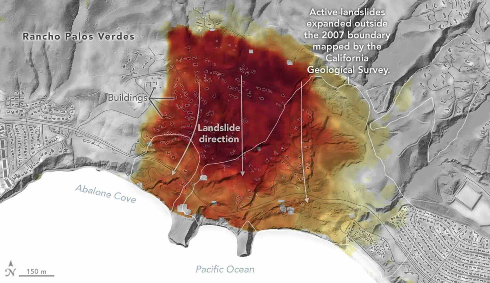
The radar recorded alarming ground movement over four flights between September 18 and October 17, 2024. Of particular concern, land that included many residential communities was found to be shifting toward the ocean at a rate of nearly four inches per week.
Visualizing the Landslide’s Growth
NASA’s data visualization represents the shifting terrain with a yellow-to-red color scale, where deep red indicates the fastest-moving areas. White boundary lines mark the extent of the landslide, as defined by the California Geological Survey in 2007. However, many dark red regions now extend beyond those boundaries, illustrating the landslide’s dramatic expansion over the past two decades.
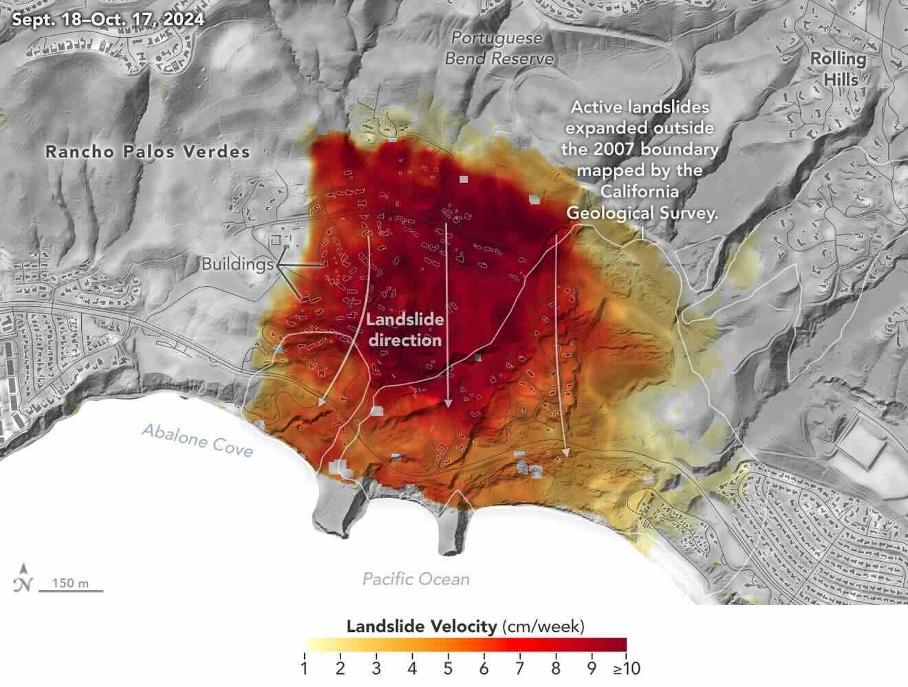
“In effect, we’re seeing that the footprint of land experiencing significant impacts has expanded, and the speed is more than enough to put human life and infrastructure at risk,” said Alexander Handwerger, the JPL landslide scientist who performed the analysis.
Just last year, the Federal Emergency Management Agency (FEMA) offered a $42 million buyout to homeowners in the area, attempting to alleviate the damage from the increasing prevalence of landslides. Due to harsh winter storms, FEMA declared the area a disaster zone between January 31 and February 9, 2024.
Continuing Efforts To Stay Ahead Of Landslides
NASA will continue supporting Handwerger’s work on landslides through the upcoming Landslide Climate Change Experiments, which he will oversee. The project will again employ airborne radar to study how weather extremes ranging from heavy precipitation to droughts impact landslides.

Unlike previous efforts focused solely on Palos Verdes, the new project will broaden its scope to include the entire California coastline.
The NASA products on the Palos Verdes landslides are available on the agency’s Disasters webpage.
Ryan Whalen covers science and technology for The Debrief. He holds an MA in History and a Master of Library and Information Science with a certificate in Data Science. He can be contacted at ryan@thedebrief.org, and follow him on Twitter @mdntwvlf.