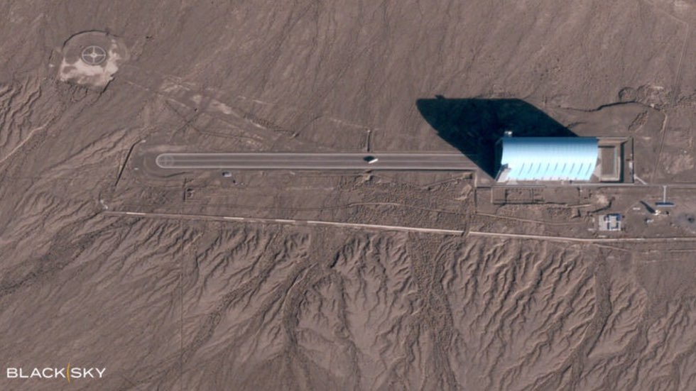
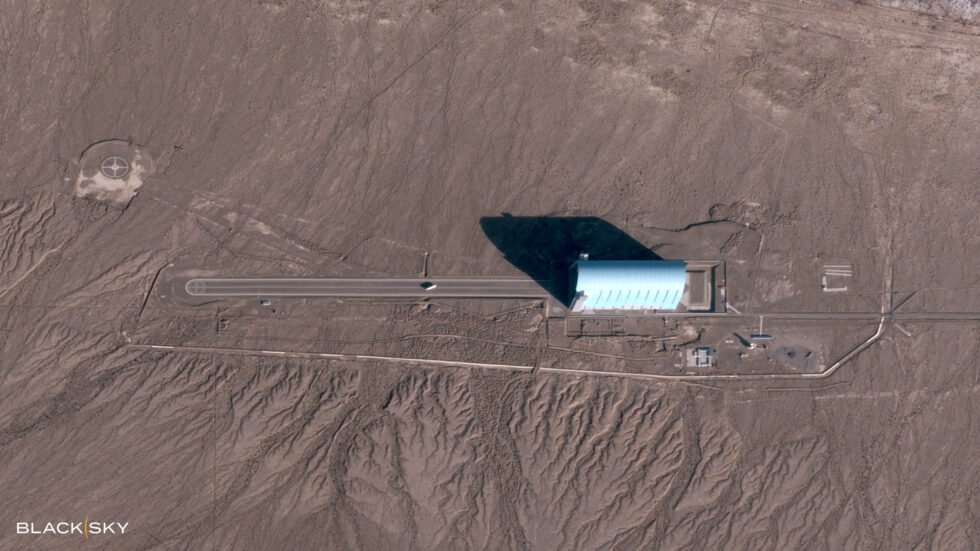
New satellite images of a suspected Chinese airship at the Korla East Test Site in Xinjiang, China, were released on Monday, also displaying alleged technologies capable of engaging foreign satellites with laser anti-satellite weapons (ASAT).
The images were released by BlackSky Technology Inc, an independent provider of real-time geospatial intelligence, according to a statement released by the company this morning.
The image, which shows what appears to be a white, oblong-shaped airship hovering above a runway at the Korla East Test Site, was obtained by the company on November 4, 2022, at 9 a.m. local time. The company says the newly released satellite photo “is one of only two images, from among more than 1,000 images collected over the duration of one year, that shows a likely airship on the ground.”


It has also been reported that satellite imagery BlackSky has obtained of the site appears to reveal the operation of laser anti-satellite weapons (ASAT), which China may be using in attempts to destroy foreign satellites or engage with them in potential hacking efforts.
Satellite hijacking attempts and other threats from space carried out by countries like China were among the concerns raised by U.S. intelligence officials in a series of several hundreds of classified U.S. intelligence documents recently leaked online by Jack Teixeira, a 21-year-old airman with the 102 Intelligence Wing of the Massachusetts Air National Guard.
Along with the alleged airship, satellite imagery obtained by BlackSky appears to show a pair of laser gimbals and other components within hangars at the Chinese test facility, seemingly confirming the presence of ASAT weapons, according to an analysis by the defense industry news source Army Technology.
The hangars containing the ASAT weapon systems appear to become operative at solar noon, which coincides with peak activity periods of intelligence imagery collection by foreign satellites.
Among the known satellites orbiting over Xinjiang, China, in early November 2022 were geo-imaging satellites operated by Spire and Planet Labs, as well as SpaceX Starlink communications satellites. Undisclosed satellites operated by the U.S. and other nations were also likely to have been active over the region.
In addition to ASAT capabilities, BlackSky’s satellite imagery also depicts what appears to be the Chinese facility’s on-site electromagnetic pulse (EMP) generator, which is used in tests involving protection and hardening of technologies against potential electromagnetic weapon attacks or other related EMP events, Army Technology also reported.
Based in Herndon, VA, BlackSky designs and operates its own low-earth orbit satellite constellations, which the company says are optimized for the collection of imagery and related data that it provides to governments around the world. This is in addition to the company’s Spectra AI software, which it uses to process the data it collects, along with data obtained from third-party sensors.
BlackSky CEO Brian E. O’Toole said on Monday that the geospatial-intelligence technology his company provides “has permanently changed how humanity will use space to deliver actionable intelligence.”
O’Toole said the images his company released were made possible thanks to BlackSky’s implementation of “the world’s first commercial high-frequency monitoring satellite constellation and AI-driven tasking and analytics platform,” which facilitates dynamic hourly monitoring that occurs up to 15 times daily.
O’Toole added that the company’s unique capabilities allow it to capture rare events and provide crucial data to U.S. intelligence agencies and other government organizations, allowing them to “stay informed about critical areas of interest in real time.”
Micah Hanks is the Editor-in-Chief and Co-Founder of The Debrief. He can be reached by email at micah@thedebrief.org. Follow his work at micahhanks.com and on Twitter: @MicahHanks.

