The strange green light flashed through the sky near Mount Fuji with tremendous speed. So quickly, in fact, that any observer who merely glimpsed it couldn’t be faulted for wondering if it might be an instance of the curious unidentified aerial phenomena currently being investigated by the United States Department of Defense.
Whatever had just flashed through the skies over Japan certainly wasn’t a bird or a plane… could it have been a meteor? Daichi Fujii knew just one thing: whatever the source of the eerie green flash had been, it was unlike anything he had seen before.
That certainly isn’t to say that the Japanese astronomer hasn’t seen some extraordinary things. The curator of the Hiratsuka City Museum, Fujii has observed plenty of rare celestial events and other phenomena in his time. He even made headlines earlier this year in March 2023, as a series of cameras he had set up to monitor the moon managed to capture a meteorite smashing into the lunar surface.
However, the peculiar green streaks of light that turned up in a video he captured during the Fall of 2022 didn’t appear to be meteor activity or anything else he recognized.
It was a genuine mystery.
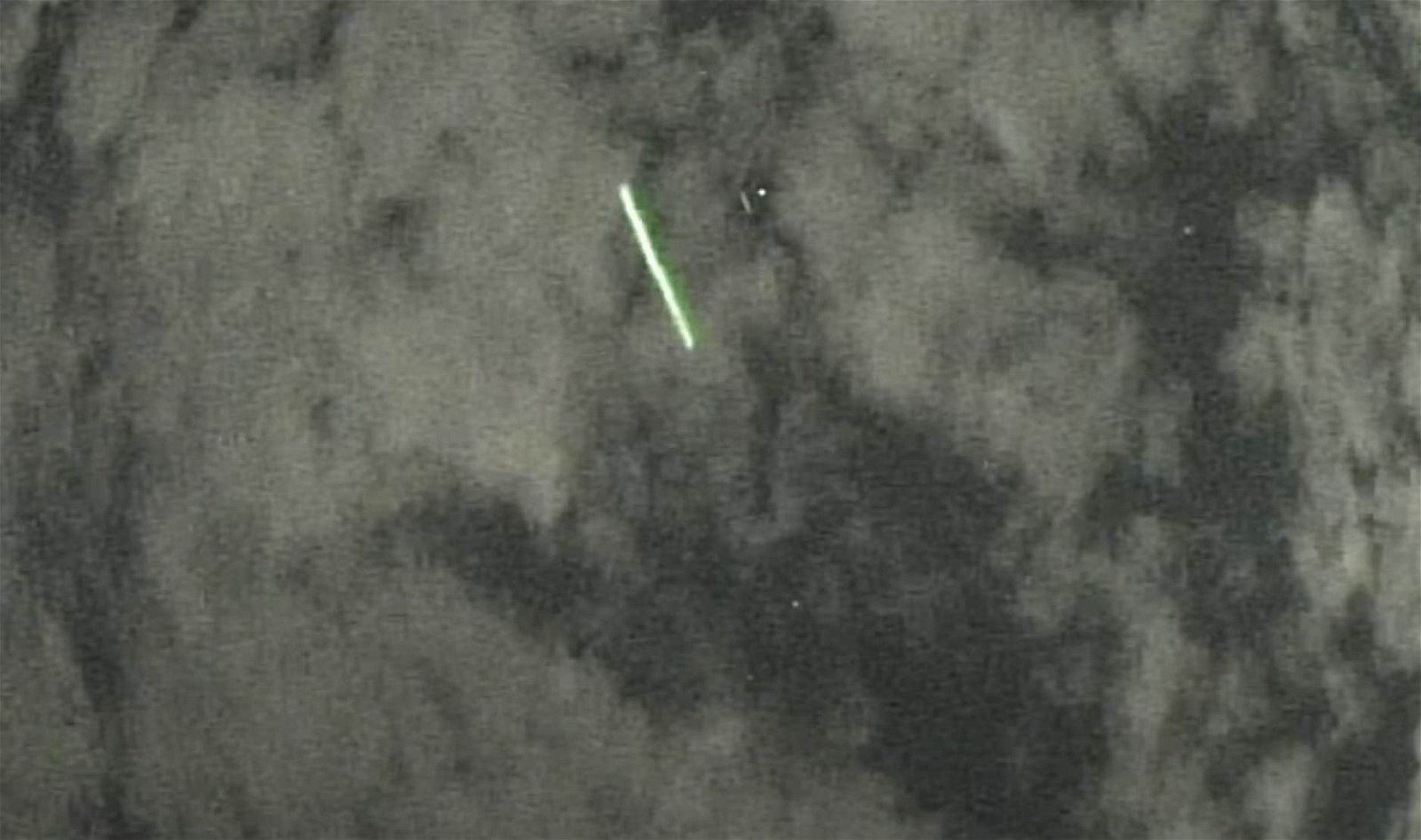
The light phenomenon was recorded on September 16, 2022, using a series of motion detection cameras operating near Mount Fuji. Although initially perplexing, Fujii began to notice something else in the videos: every time the odd green streaks of light appeared in the footage, so did a very small green dot.
Could it have been an object in orbit, perhaps even a satellite? Determining whether this had been the case would be easy since the position of the cameras on one of Japan’s famous landmarks, along with the known time and date that the footage was captured, would allow any correlations with satellites passing overhead to be calculated with ease.
Checking with NASA satellite data, Fujii searched for any possible matches with objects being tracked in Earth’s orbit. Eventually, his search brought him to information on the position of the Ice, Cloud, and Land Elevation Satellite 2, otherwise known as the ICESat-2.
Fujii finally had a match.
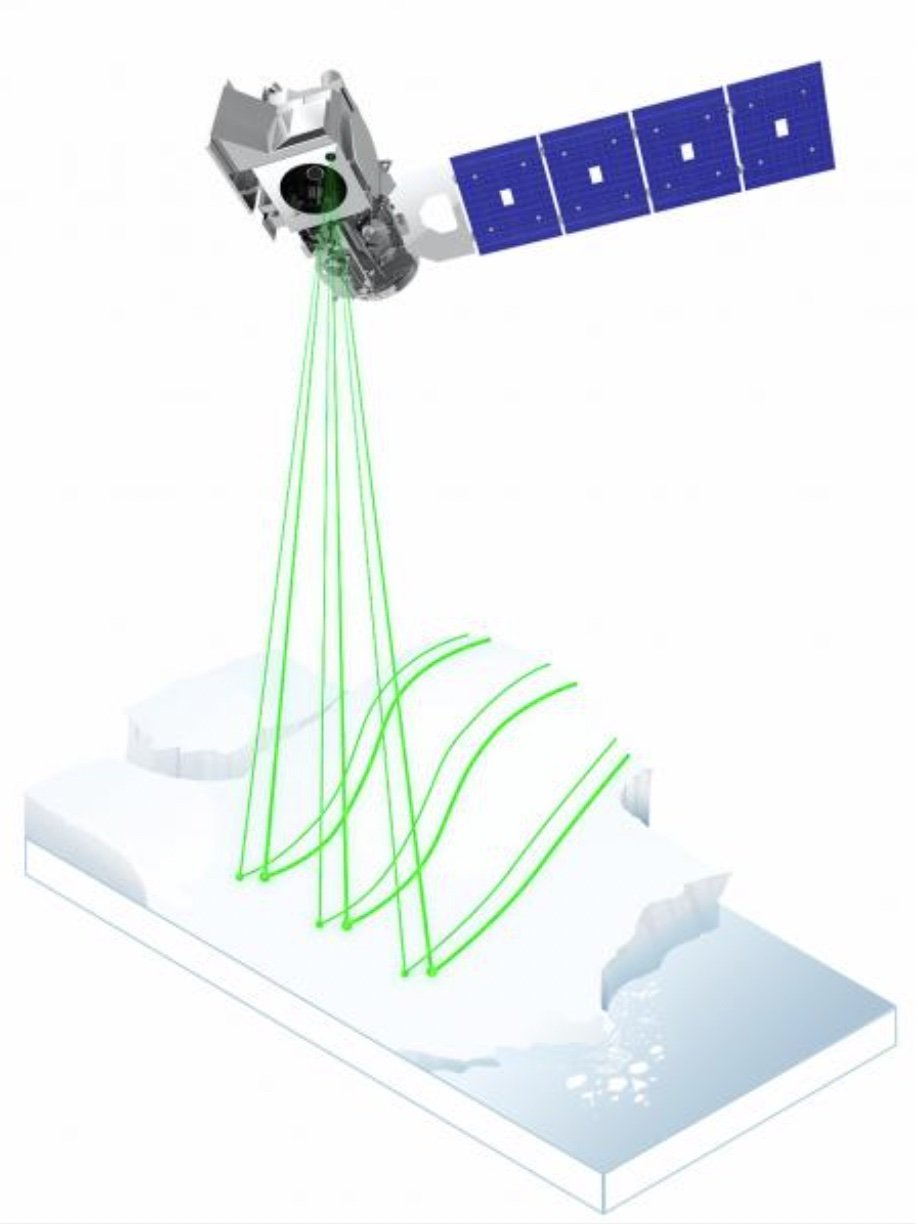
As part of NASA’s Earth Observing System, ICESat-2’s main job involves taking measurements of the thickness of sea ice, as well as ice sheet elevation, and a range of topographical features, as well as cloud formations from its position in orbit.
From its height of around 308 miles (496 km), the satellite’s near-polar orbit on September 16, 2022, brought it directly over Mount Fuji, meaning that it had been the likely culprit behind the phenomenon in the footage Fujii recovered. Especially since ICESat-2 actually does beam lasers toward Earth as it passes overhead.
However, the satellite’s lasers had never been caught on film prior to the chance detection Fujii accomplished with his motion-sensing camera array since seeing the satellite’s beam from the ground can be very tricky.
In fact, the instruments on board the satellite, even if one were standing in the precise position on the ground, might only resemble a distant camera flash in the sky if seen with the naked eye from Earth.
“ICESat-2 appeared to be almost directly overhead of him, with the beam hitting the low clouds at an angle,” according to scientist Tony Martino, who works as an ICESat-2 instrument specialist at NASA’s Goddard Space Flight Center in Greenbelt, Maryland.
First launched in the Autumn of 2018, ICESat-2 employs LiDAR, or light detection and ranging (sometimes also “laser imaging, detection, and ranging”). This remote sensing technology works similarly to radar but uses lasers it bounces off objects and measures the time required for it to bounce back and return to the unit’s receiver, which allows it to make exceptionally accurate measurements.

The ICESat-2’s powerful LiDAR allows it to collect accurate measurements of the ice, water, cloud formations, and surface regions of Earth from its position in low Earth orbit by firing its laser pulses around 10,000 times every second, producing six beams that are fired toward Earth. As the beams are bounced off features on the planet below, the satellite measures the return rate of individual photons, which have been successfully used to help derive calculations of things that include the height of water levels in reservoirs to the increase in loss of ice from locations like Greenland and Antarctica in recent years.
In the past, attempts to photograph ICESat-2 have been made, with two successful attempts occurring in Oklahoma and in Chile. Capturing its distinctive green beam is another story, however, as it requires having something for the laser’s light to reflect off of.
In Fujii’s case, his cameras not only happened to be in a perfect position as the satellite passed overhead, but the right amount of cloud coverage existed to allow the laser to scatter the laser’s light, similar to shining the beam of a powerful flashlight through smoke or heavy fog. Fortunately, the cloud coverage was also moderate enough that it didn’t block the lasers from view altogether.
Seeing the laser obviously isn’t easy, and according to Martino, requires an age-old formula: being in the exact right place at the right time.
“And you have to have the right conditions,” he adds. Fortunately, Fujii seems to have had them, which allowed the source behind the mysterious green flashes he captured on film to be reconciled with the ICESat-2 data available to researchers like Martino, marking another successful resolution to a mystery with help from NASA satellite data.
You can learn more about the ICESat-2 and its mission on its official page, which includes global data it collects and a range of interactive features.
Micah Hanks is the Editor-in-Chief and Co-Founder of The Debrief. He can be reached by email at micah@thedebrief.org. Follow his work at micahhanks.com and on Twitter: @MicahHanks.