Off the Central California coast near Big Sur, a massive field of seafloor holes spans an area roughly the size of Los Angeles, the origins of which have long perplexed researchers.
The unusual formations, known as pockmarks, date to prehistoric times and were long theorized to represent areas where methane gas eruptions have occurred over time, helping the depressions maintain their characteristic shape and appearance.
Now, research completed by the Monterey Bay Aquarium Research Institute (MBARI), the U.S. Geological Survey, and Stanford University has upended the previously held notion that these unusual depressions are maintained by methane activity and instead are preserved by sediment flows.
The new findings provide significant new data that could assist with seafloor management, particularly in areas that could become the future home of offshore wind farms.
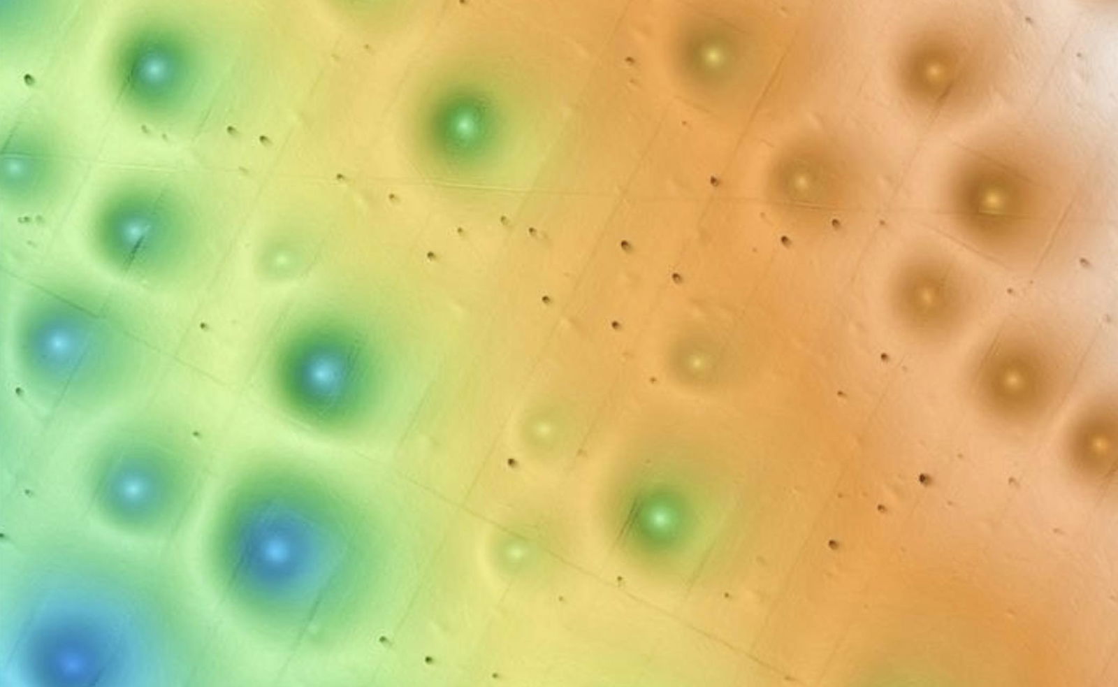
A new study detailing the research team’s work, which appeared in the Journal of Geophysical Research: Earth Surface, details their analysis of the Sur Pockmark Field on the lower continental slope off the coast of Big Sur, where close to 5,200 circular depressions exist.
Initially discovered during EM-300 multi-beam bathymetric surveys, the pockmarks, each close to 200 meters wide and five meters deep, were once believed to have been formed by pockets of methane gas emitted from the ocean floor, resulting in the large crater-like formations.
If methane were indeed capable of disturbing the seafloor in this way, it could potentially represent problems for utilizing areas off the Central California coast for offshore wind farms since seafloor stability would naturally come into question. However, past studies have already shown that there was no present-day indication of fluid or gas venting that occurred within these depressions, although their sedimentology indicated that they were likely to have formed more than 45,000 years ago.
With the help of underwater robots provided by MBARI, the researchers produced detailed new maps of the Sur Pockmark Field. Deploying autonomous underwater vehicles, or AUVs, capable of obtaining high-resolution terrain visualizations and remotely operated vehicles (ROVs) to collect sediment samples, the researchers were able to peer back in time at the history of the formation of the pockmarks, which revealed a few surprises.
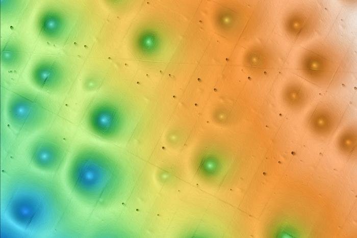
Of key significance, the data the research team collected revealed no evidence of methane in the area, instead pointing to the sedimentary processes occurring in the area as the driving force behind the pockmarks.
Sediment gravity flows, which the researchers liken to underwater avalanches, instead appear to be the culprits behind these unusual seafloor holes, which have shaped them over hundreds of thousands of years.
“While some pockmarks occur in chains, most are not clustered or randomly spaced but are regularly dispersed within the pockmark field,” the researchers write in their new study.
“We hypothesize that intermittent, unconfined sediment gravity flows occurring over at least the last 280,000 years are the source of the regionally continuous turbidite deposits and the mechanism that maintained the regularly dispersed pockmarks,” the researchers conclude.
The new findings provide a more complete understanding of the sedimentary processes off the California coast and how the stability of infrastructure like turbine anchors can be maintained in the future as the critical need for new green energy sources continues to rise amid increased occurrences of severe weather events.

Additionally, the research will aid in the future management of offshore developments, in addition to contributing to better seafloor management through an increased understanding of the implications of such operations on the environment.
MBARI Senior Research Technician Eve Lundsten, who led the research, said there is still much work to be done and that many unresolved questions remain about the processes occurring on the seafloor.
“We were unable to determine exactly how these pockmarks were initially formed, but with MBARI’s advanced underwater technology, we’ve gained new insight into how and why these features have persisted on the seafloor for hundreds of thousands of years,” Lundsten said in a statement.
“This research provides important data about the seafloor for resource managers and others considering potential offshore sites for underwater infrastructure to guide their decision-making,” Lundsten said.
Lundsten and her colleagues’ findings not only shift the narrative on how these underwater features are maintained but also significantly reinforce the need for continued marine research to guide future offshore development and environmental stewardship.
Micah Hanks is the Editor-in-Chief and Co-Founder of The Debrief. He can be reached by email at micah@thedebrief.org. Follow his work at micahhanks.com and on X: @MicahHanks.