On February 8, the latest volcanic eruption in an ongoing series of similar incidents occurred on southwestern Iceland’s Reykjanes peninsula.
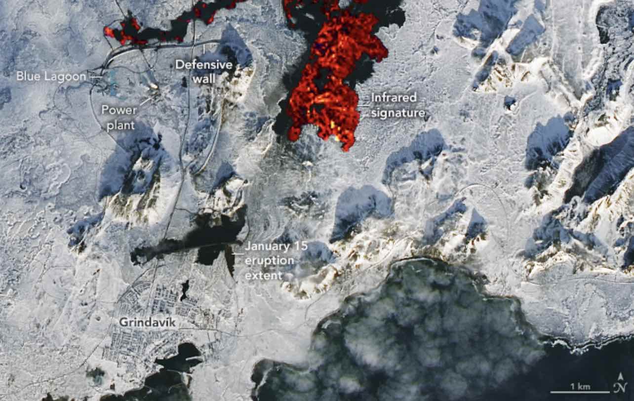
Erupting from a fissure located close to Mount Sýlingarfell, the eruptions have impacted the nearby village of Grindavík since volcanic began in Iceland late last year following a period of earthquake activity.
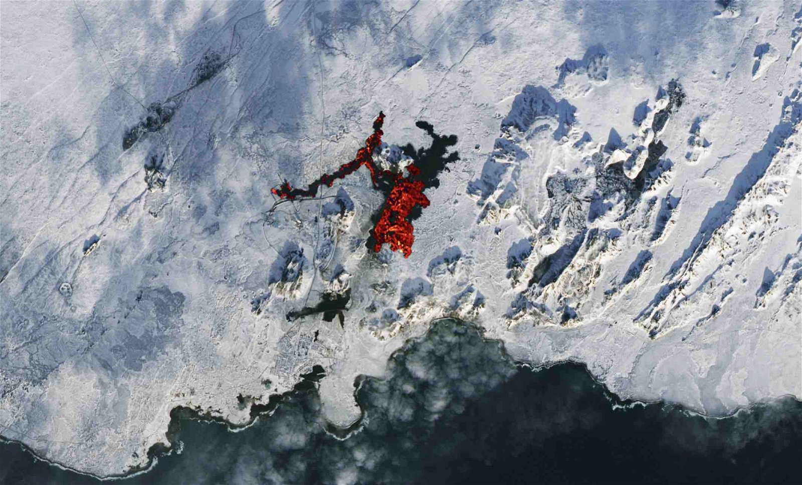
Now, recent satellite images are not only offering a glimpse of the latest eruption on the island in unprecedented detail, but they are also revealing the extent of the heat produced by the resulting lava flows, as well as the composition of the volcanic plume.
Imagery collected on February 10, 2024, by the Operational Land Imager-2 (OLI-2) instrument on NASA’s Landsat 9 satellite was combined with natural color satellite imagery, which the agency featured on NASA’s Earth Observatory website.
The images convey not only the heat being generated by the recent lava flows but also the existing lava from eruptions earlier this year that have now begun to cool.
The plume of gas and ash spewing toward the southwest was also photographed by NASA’s Terra satellite using its Moderate Resolution Imaging Spectroradiometer (MODIS) instrument. The plume is likely composed of a combination of water vapor, sulfur dioxide, carbon dioxide, and also a moderate number of other gases and volcanic byproducts.
Simon Carn, a volcanologist with Michigan Technological University, shared images online based on data obtained with the Tropospheric Monitoring Instrument (TROPOMI) on the Copernicus Sentinel-5 Precursor mission, an effort jointly funded by the ESA and the Netherlands that provides data based on its monitoring of Earth’s atmosphere.
As sunlight gradually returns to high northern latitudes, so does UV satellite monitoring of #volcanic SO₂ emissions from #Iceland. #Sentinel5P #TROPOMI detected SO₂ from today’s #eruption on the #Reykjanes peninsula drifting over the N. Atlantic. @BIRA_IASB @Vedurstofan pic.twitter.com/AGcmJbb5Ld
— Prof. Simon Carn (@simoncarn) February 8, 2024
Data relayed by the TROPOMI instrument indicated that sulfur dioxide was also detected within the plume of the February 8 eruption.
Most of the lava from the recent eruption flowed east, avoiding Grindavík to the south, and barriers were successfully able to protect a power plant and a spa that were close to the path of the recent lava flows.
Damage was incurred to several roads and a main pipeline for hot water, and efforts to repair the damaged areas and restore hot water to the area have remained underway.

The Icelandic Meteorological Office reported that its hazard assessment has been updated following the recent eruptions and that changes were made for some zones.
“The overall hazard assessment for the area remains unchanged from the last map,” the office said on its website, adding that sinkholes and fault movements are still being reported near the vicinity of Grindavík.
As of February 9, most of the seismic sensors in the region were no longer detecting tremors associated with volcanic activity, and drone footage obtained near the most recent eruption site showed no signs of activity.
Although conditions appear to have calmed near the location of the most recent eruption, officials say they are continuing to monitor apparent land surface swelling that was detected above a magma reservoir close to Svartsengi.
The Icelandic Met Office said it was “highly likely that the cycle continues in a few weeks with another dyke propagation and a volcanic eruption,” based on conditions near the reservoir similar to those observed at the locations where other recent eruptions in the area have occurred.
Micah Hanks is the Editor-in-Chief and Co-Founder of The Debrief. He can be reached by email at micah@thedebrief.org. Follow his work at micahhanks.com and on X: @MicahHanks.